
 I spent this morning hiking from the base of Brighton Ski Resort up to Sunset Peak and the Great Western Trail. It's a hike of around 5.5 miles round-trip, with an elevation change of around 1,600 feet (from the Brighton parking lot - 8,800 or so feet - to Sunset Peak - 10,400 or so feet). The trail runs through the Wasatch-Cache National Forest the entire way, and while it absolutely kicked my ass physically, it was a rich reminder of why this place is special, and why Im always compelled to return.
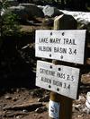
The trail begins in Brighton's parking lot, and for the first mile or so I wound under chairlifts and across ski trails, gaining elevation rapidly as I went. The first milestone on the hike is Lake Mary, a deep, blue, and clear mountain lake where I went fishing with my father as a kid, and where my older brother went marauding with young women as a teenager.
![]() Most hikers stop at Mary, but I continued on, climbing higher, past little, green Lake Martha, and ultimately climbing to a cirque from which I enjoyed a fantastic view of Lake Mary, Brighton, and the opposite side of Big Cottonwood Canyon. It's on the climb to this cirque that I lost the trail in the snow pack ... of course, when in doubt of the trail, my motto is "climb straight up," which I did, and which in retrospect, may not have been particularly bright.
Most hikers stop at Mary, but I continued on, climbing higher, past little, green Lake Martha, and ultimately climbing to a cirque from which I enjoyed a fantastic view of Lake Mary, Brighton, and the opposite side of Big Cottonwood Canyon. It's on the climb to this cirque that I lost the trail in the snow pack ... of course, when in doubt of the trail, my motto is "climb straight up," which I did, and which in retrospect, may not have been particularly bright.
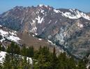
Regardless, it's this cirque, formed by Mt. Tuscarora, Sunset Peak, and Pioneer Peak, that holds Lake Catherine. Climb to the top of the ridge, and you're shortly on the Great Western Trail and up to the panorama of Sunset Peak. At this altitude, the ground is increasingly barren, but even with the large amount of snow pack still on the ground, the early wildflowers were making their appearance.
 After another 120 feet of vertical I finally reached Catherine Pass. I enjoyed the view for a minute, then trekked along the ridgeline another .3 miles until I intersected the Great Western Trail. An amazing thing, intersecting a trail like the Great Western, a thing of inherent possibility: turn right, and hike mountains and deserts South all the way to Mexico; turn left, and hike ridgelines and plains North all the way to Canada.
This time, though, I did neither, instead making a short climb to Sunset Peak and its extraordinary 360-degree panorama. With today's clear blue sky, from here I could see Mt. Timpanogos to the South, the Unita Mountains on the Wyoming border to the Northwest, all of Brighton, and in Albion Basin, the Alta parking lot and the top of the Snowbird Tram (elevation 11,000).
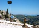 You're at altitude at Catherine Pass, around 10,200 feet ... in the winter, the snow here is 10 to 20 feet deep (as this snap of me next to a ski resort boundary sign illustrates ... in the winter, this sign is supposed to be at eye-level). I was completely alone, unless you count my friend the chipmunk and his somewhat more adventurous cousin, the "pot gut."
It was quiet, warm, and beautiful. My legs ached, but it was worth the climb. I sat on a warm rock at the top of the peak, closed my eyes, and listened to the wind, birds, flies, and bees. It took two hours to make the climb, and after 30 minutes on top, I started down. As I retraced my steps (managing to keep the trail this time) I met other knots of climbers, in twos and threes, making their way up.
"How is it?" they'd ask.
"Wonderful," I'd say, knowing all the while that in having had the cirque to myself all morning, Id also already had the best hike of the lot.
Posted by Avocare at June 8, 2003 03:49 PMme and crazy Janie making love in the dirt, singing our birthday songs. . . .
Posted by: john at June 8, 2003 05:46 PMThanks for signing in, . Now you can comment. (sign out)